Connections to Africa
Deadline: Monday, October 15, 2012 by 08:00

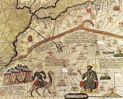
Take a look at this Catalan map from 1375 and answer the questions below on the blog:

1. What parts of the world are featured on the map?

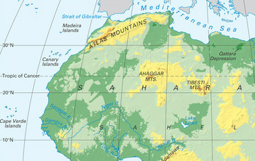
2. What do you think is the brown curved path featured at the top right of the map? (Hint: Look at the map pictured below for a clue!)

3. Who is pictured on his throne on the bottom right of the map?

4. Why do you think this African king mentioned in question 3 has been featured on the map? What did he do that made him so famous to be pictured on a map?


Nicole xxxx
9/10/2012 04:51:40 am

Q 1- I think that the countries and cultures found on the map are: Egypt, India, Africa, and the Native Americans.

Q 2- I think that the path represents the connecting path between the north Sahara and the bit of land above it (Strait Gibraltar). Maybe it was very significant to that tribe.

Q 3- In the bottom right hand corner of the map, I see an African King, claiming his glory from finding the escape way, out of the Sahara, this made him famous.

Q 4- He became famous from finding the escape way, out of the Sahara, and creating his own tribe, this made him famous and well- known, to go on the map of the Sahara.

Reply
Lauren A
9/10/2012 04:58:34 am

1. The part featured in this map is west Africa.
2. I believe that this brown looking pathway on the map is a way of representing the Atlas Mountains.Real answer."In quest of a sea route around the Atlas mountains."http://www.world-mysteries.com/sar_10.htm
3. "Image of an Saracen king of West Africa, believed to be Mansa Musa, Emperor of Mali. From the Catalan Atlas of 1375, composed by cartographer Abraham Cresques of Majorca." website http://en.wikipedia.org/wiki/File:African_king_from_Catalan_Atlas_(1375).jpg.
4. The African king was put on that spot in the map because that is where he made most of his wealth.

Reply
kuzeyyyyyyy :)
10/10/2012 03:50:04 am

1 I think the map is South Africa or West Africa.
2.For me,it is featured in Sahara.
3.The king of Africa.
4.Because he covered all the South Africa.

Reply
Jonesy
10/10/2012 04:20:03 am

1. I think the continent on the map is West Africa.
2. I think the brown path on the map is a bridge or road connecting Africa (through the Atlas mountains) to Western Sudan and so they can trade goods and travel easier.
3.The person on the throne in the bottom right corner is Mansa Kankan Musa, King of Mali empire.
4. Mansa Musa was (is) famous for is Hajj (or Pilgrimage) to Mecca. On this pilgrimage The King brought 60,000 people (12,000 were servants), 300 pounds of gold carried by Camels and gave it to the poor. He was also famous because he reigned the Mali Empire for 25 years. He developed the worship of Islam in Africa, upgraded education and brought order to his empire and Africa.

Reply
giodi:)
10/10/2012 05:01:07 am

Reply
mr hendricks
11/10/2012 01:28:58 am

silence is powerful but we need words on this blog

Reply
Jonesy
11/10/2012 11:06:10 pm

You didn´t put anything on the blog !!!

Reply
someone who lear history in ESIS
12/10/2012 01:29:26 am

Why you didn't put anything on the blog

Reply
someone
12/10/2012 01:34:21 am

Why you didn't put anything on the blog.......

Reply
lacky quess who i am
11/10/2012 01:27:21 am

Question 1 = I think the countries on the map are africa and north and south africa it also looks like there is another country on the picture two. but i can't put my finger on what it is.

Question2= I think that footpath is maybe a bridge or path to take to another place or it could be like a special temple.

Question3= I think the person on the bottom right is the king of the whole of africa or maybe just the north of africa, or maybe he is just like the ruler of the town

Question4= The king may have become the king by his relatives or he could have maybe saved some peoples live or he could just be seriously rich.

Reply
wert
11/10/2012 11:55:50 pm

you are luca

Reply
Tinaaaaaaa Sindlerova
12/10/2012 01:24:00 am

Q1: I think is West Africa because you can see Canary Islands in the map below. And its is fourteenth century.
Q2: I think is bridge.
Q3: Is African King called "Mansa Musa" King from Timbuktu. And he is King of Mali. I think this because i saw the video :Section 3 trading kingdoms of West Africa .Video called "Mansa Musa"
Q4: He designed numerous buildings for the Emperor including a new palace named Madagou, the Gao mosque at Gao, the second largest city in Mali, and the still-standing great mosque at Timbuktu, the largest city in the empire. That mosque was named the Djinguereber. http://www.blackpast.org/?q=gah/musa-mansa-1280-1337

Reply
mr feliu
12/10/2012 04:12:21 am

1) the map it's located in the atlas mountains, north west of Africa
2) I think that the brown curved path, means the way that Mansa Musa, the king mentioned on the third question , followed to peregrinate to Mecca, I think that, because I searched for the map in internet, and I found that the path continued towards Mecca.
I found it in this website:
http://www.bridgemanart.com/asset/56621/Spanish-School-14th-century/Catalan-Atlas:-Detail-of-North-Africa-and-Europe-

3)The king featured in the map is called Mansa Musa the king of Mali.
4) I think that Mansa Musa is very important and famous because was the richest person in those times, and probably the richest ever if we consider the inflation. In addition when he was peregrinating to Mecca, he gave gold to poor people that he met along the way, and built a mosque each Friday in different villages

Reply
Chris
12/10/2012 07:46:08 pm

1. I think that is west África and India
2.I think that the Brown curved path is a bridge
3.is an african King of north África
4.made most famous by Abbott and Costello. In Abbott and Costello's version, the premise of the routine is that Abbott is identifying the players on a baseball team to Costellobut their names and nicknames can be interpreted as nonresponsive answers to Costello's questions

Reply
giodi:)
12/10/2012 08:04:55 pm

1. I think that is west africa.
2. I think that the brown curver path is a brige
3.That person that is sitting on the throne is the king of north africa.
4.Mansa musa is famous because he was the richest person in those times.he gives money to the poor people.

Reply
Miss Sindlerova
12/10/2012 08:15:03 pm

Mr.Giordi you have the same answer like Mr.Chris Q2......

Reply
Artur Ganeev
12/10/2012 08:24:13 pm

1.i think it is North-West Africa.
2.I think there Atlas Mountain.
3.I think here is depicts King Mali Kankan Musa.
4.He was treated fairly to slaves. There was peace in Mali when he was king.He controlled gold mines. But he appeared on the map because of his richness. And there is an Arab on the map near the king.That shows there was perfect trade in Mali.

Reply
Tarzan
12/10/2012 09:18:28 pm

Question:1
I think the parts of the world that are featured in the map is north west of Africa.

Question 2:
For me, the brown curved path featured at the top right of the map is a road crossing the Atlas Mountains from west to east.

Question 3:
I believe the person on the throne in the bottom right of the map is Mansa Musa, king of Mali.

Question 4:
This King (Mansa Musa) king of Mali is featured in this map because he is famous for his pilgrimage to Mecca. He is also very famous for building libraries, universities, and spacious mosques. He was a supporter of education, and his generosity provoked the decrease of gold price.

Reply
shazzybo
13/10/2012 06:21:52 pm

Question1: I believe that the two countries in the picture are Africa and North America.

Question2: I think it looks mostly like a brick path and it could be connected to all different tribes or countries.

Question3: The man at the bottom right might be a King, God or a ruler of his own nation.

Question4: The King could have became a King because he was rich, he had connections with royalty or he could have done something that made him heroic or taking out a klan or a bad tribe.

Reply
Timoshka
13/10/2012 10:35:14 pm

1. On the picture, I can see Sahara ( Located in North Africa) and Mediterranean Sea.
2. I think that the brown curved path featured at the top right of the map presents where the Atlas Mountans start.
3. Man that is sitting on throne on the bottom right of the map is ann sfrican king named: Mansa Musa. And Masa Musa is the king of Mali.
4. I think that Mansa Musa is pictued on the map, because at that time he was probably the most famous, rich and loved by people from Africa.

Reply
Batman
14/10/2012 04:57:00 am

1 I think it South or West Africa
2 I think it is Algeria
3 It is the King of Africa
4 because he covered all Africa

Reply


Leave a Reply.

    7TH GRADE

    The rules are simple:

    1. Check this blog every Monday. Blog writing is part of your homework grade.

    2. Write a comment of 5 sentences or more on the weekly blog post or on another student's response.

    3. Use correct capitalization and punctuation when writing.

    4. Go back and read your comment again OUT LOUD. (This can be to your computer screen or to your dog, if you have one). Edit your mistakes.

    5. Make sure your commentary is clean and respectful.

    Archives

    November 2012
    October 2012
    September 2012

    Categories

    All